
Introduction: The Scale Problem in Fisheries Data Collection
Fisheries science has never been more ambitious — or more data-hungry. Conservation programs now track individual fish across entire river basins spanning thousands of kilometers. Hatchery programs release millions of juveniles annually and demand individual-level survival data. Regulatory compliance frameworks require statistically robust population assessments updated on annual or even seasonal timescales.
The data collection infrastructure required to support these ambitions is enormous. And the gaps between what programs need and what traditional methods can deliver are widening every year.
Conventional sampling approaches — electrofishing surveys, gill net sampling, and visual snorkel counts — generate fragmented, labor-intensive datasets that capture population snapshots rather than continuous behavioral records. When scaled to basin-wide or multi-jurisdictional programs, these methods become logistically unmanageable and prohibitively expensive.
Modern fish tagging systems built for large-scale data collection are redefining what is scientifically achievable at scale. By combining passive integrated transponder technology with automated detection networks, centralized data management platforms, and standardized field protocols, today’s fish tagging programs are closing the gap between research ambition and operational reality. This article examines the specific challenges that scale introduces — and how modern fish tagging infrastructure addresses each one systematically.
Challenge 1: Managing Millions of Individual Identities
The Identity Management Problem
A hatchery releasing 500,000 juvenile chinook salmon in a single season generates 500,000 unique tag codes that must be accurately recorded, associated with biological metadata, and maintained in a searchable database for the lifetime of the monitoring program — potentially a decade or more. Multiply this across dozens of release sites, multiple species, and multiple agencies sharing detection infrastructure, and the identity management challenge becomes immediately apparent.
Manual database entry at this scale is not merely inefficient — it is a structural source of error. Transcription mistakes, duplicate entries, and metadata misattribution accumulate across large datasets in ways that are difficult to detect and nearly impossible to correct without comprehensive audit trails.
How Modern Fish Tagging Addresses It
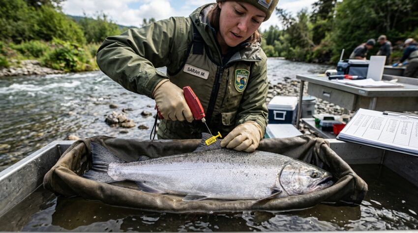
Contemporary fish tagging programs use automated tag scanning integrated directly with database management systems. At hatchery release sites, fish pass through automated scanning tunnels that record each tag code, log biological metadata collected during tagging, and upload records to centralized databases in real time — without manual data entry at any stage of the process.
Large institutional databases like PTAGIS in the Columbia River Basin demonstrate the scalability of this approach. With over 180 million detection records from more than 7 million unique tagged individuals, PTAGIS operates as a multi-agency shared infrastructure platform where automated data collection, quality control algorithms, and standardized metadata schemas maintain data integrity across an enormously complex program.
Challenge 2: Geographic Coverage Across Vast Watersheds
The Coverage Gap Problem
A fish tagged at a hatchery in the upper Snake River may migrate through eight states and two countries before returning to spawn three years later. Tracking that individual’s complete migration history requires detection infrastructure distributed across thousands of river kilometers — infrastructure that no single agency can afford to install and maintain independently.
Traditional monitoring approaches respond to this coverage problem by accepting incomplete data. Fish are detected at a few high-priority locations and assumed to have passed undetected through intervening reaches. These assumptions introduce uncertainty that compounds across survival models and population assessments.
How Modern Fish Tagging Addresses It
Multi-agency detection networks built around standardized fish tagging technology solve the coverage problem through infrastructure sharing. When all participating agencies use ISO-compatible tags and readers, detection records from hundreds of monitoring sites operated by different organizations can flow into shared databases without compatibility barriers.
The Pacific Northwest’s collaborative detection network illustrates the power of this approach. Federal agencies, tribal fisheries programs, state fish and wildlife departments, and university research programs all contribute detection data to PTAGIS using standardized fish tagging protocols. The result is a detection network with geographic coverage that no individual participant could sustain independently — coverage that makes basin-wide survival modeling statistically credible.
VodaIQ, VodaIQ, supports multi-agency fish tagging programs by providing ISO-compliant tagging hardware and compatible detection systems that integrate seamlessly into shared monitoring networks, eliminating the compatibility barriers that fragment large-scale data collection efforts.
Challenge 3: Real-Time Data Transmission from Remote Locations
The Remote Access Problem
Some of the most ecologically important fish monitoring locations are also the most logistically challenging. Headwater tributaries critical for bull trout spawning, remote canyon reaches used by steelhead, and offshore estuarine zones supporting juvenile salmon rearing are often far from road access, electrical infrastructure, and cellular coverage.
Traditional monitoring at remote sites requires periodic physical visits to download stored data — an approach that introduces temporal gaps, creates data loss risks if storage devices fail between visits, and limits a program’s ability to respond dynamically to observed migration events.
How Modern Fish Tagging Addresses It
Solar-powered detection stations paired with satellite or long-range radio data transmission have transformed remote monitoring capacity in fish tagging programs. Modern antenna arrays equipped with low-power microcontrollers can operate continuously on solar power, storing detection records locally and transmitting data packages to centralized servers via satellite uplink or LoRaWAN radio networks on user-defined schedules.
This infrastructure eliminates the temporal gaps that plagued earlier remote monitoring approaches. Program managers can now access detection records from remote sites within hours of the detection event — enabling real-time migration tracking, rapid response to unexpected movement patterns, and immediate identification of antenna malfunctions that might otherwise go undetected for weeks.
Challenge 4: Standardizing Protocols Across Multiple Field Teams
The Protocol Consistency Problem
Large-scale fish tagging programs commonly involve dozens of field crews operating simultaneously across geographically dispersed sites. Variation in tagging technique, anesthesia protocols, tag placement, and data recording practices between crews introduces systematic inconsistencies that complicate data interpretation.
If one crew implants tags in the peritoneal cavity while another uses muscle tissue implantation, tag retention rates may differ systematically between cohorts — a confounding variable that corrupts comparative survival analyses if not documented and controlled.
How Modern Fish Tagging Addresses It
Standardized training programs, written field protocols, and digital data collection tools reduce inter-crew variability in large fish tagging programs. The American Fisheries Society’s published guidelines for fish tagging provide a widely adopted baseline that multi-agency programs can reference to ensure methodological consistency across participating organizations.
Digital field data collection apps that enforce required data fields, validate entries against acceptable ranges, and flag procedural anomalies in real time are increasingly standard in professionally managed fish tagging programs. These tools shift protocol compliance from an honor system to an auditable, documented record — a critical distinction when data quality is subject to regulatory scrutiny.
Challenge 5: Long-Term Data Accessibility and Institutional Continuity
The Institutional Memory Problem
Fisheries monitoring programs routinely span decades. Personnel change. Agencies reorganize. Database platforms are upgraded or replaced. In programs where data continuity is essential for trend detection and population trajectory modeling, the loss of historical records or the corruption of metadata schemas during system transitions can permanently degrade analytical capacity.
How Modern Fish Tagging Addresses It
Modern fish tagging data management platforms are built around open, standardized data formats that remain accessible across software generations. Metadata schemas aligned with international biodiversity data standards — including Darwin Core and OBIS-compatible formats — ensure that detection records remain interpretable and interoperable regardless of the specific database platform used at any point in a program’s history.
Cloud-based storage with redundant backups eliminates the physical media failure risks that destroyed historical datasets in earlier monitoring eras. Programs that established fish tagging databases on server hardware in the 1990s have migrated records to cloud platforms without data loss — preserving detection histories that now represent irreplaceable ecological baselines.
Real-World Scale: Programs Setting the Standard
Columbia River Basin Monitoring
The Columbia River Basin fish tagging program represents the largest coordinated fish monitoring effort in the world. Over 30 detection sites, millions of tagged individuals, and data contributions from federal, tribal, state, and academic partners produce a dataset that directly informs federal hydropower operation decisions, tribal harvest negotiations, and endangered species recovery assessments — all simultaneously.
European Atlantic Salmon Monitoring
Across European river systems, coordinated PIT-based fish tagging programs operating under the North Atlantic Salmon Conservation Organization (NASCO) framework are generating basin-scale migration data for Atlantic salmon populations. Standardized tagging and detection protocols enable cross-national data comparisons that individual country programs could not produce independently.
New Zealand Diadromous Fish Monitoring
New Zealand’s national diadromous fish monitoring program uses standardized fish tagging protocols across river systems throughout both main islands, building a nationally consistent dataset for species including longfin eel, shortfin eel, and lamprey — data that informs both conservation planning and customary harvest management under Treaty of Waitangi obligations.
Key Investments That Make Large-Scale Programs Succeed
Programs seeking to build robust large-scale fish tagging infrastructure should prioritize:
- Centralized database architecture with role-based access controls supporting multi-agency data contribution
- Automated detection hardware reducing dependence on manual data collection at high-volume sites
- Remote transmission capability eliminating temporal gaps in data from geographically isolated monitoring stations
- Standardized training programs ensuring methodological consistency across distributed field teams
- Open data format adoption protecting long-term data accessibility against platform obsolescence
- Quality control automation flagging data anomalies in real time rather than during post-season review
Conclusion: Scale Is Solvable With the Right Infrastructure
The data collection challenges inherent in large-scale fisheries monitoring are real — but they are not insurmountable. Modern fish tagging programs, built on standardized passive integrated transponder technology, automated detection networks, remote data transmission infrastructure, and institutionally robust database platforms, have demonstrated that basin-scale, multi-decade individual-level monitoring is operationally achievable.
The programs that have made this investment — in the Columbia River Basin, across European salmon rivers, and throughout New Zealand’s diadromous fish communities — are generating the most scientifically credible, policy-relevant fisheries datasets in history. As fisheries management faces increasing complexity from climate disruption and growing harvest pressure, the scalability of modern fish tagging infrastructure is not a technical nicety. It is the operational foundation that conservation science cannot afford to be without.